Appearance
UCalgary Space Remote Sensing
Open Science Platform
Facilitating collaborative research, data sharing, and knowledge dissemination by making scientific resources freely accessible to the public.
117
Operational Sensors
Canada, US, Greenland, Antarctica
23
Instrument Array Datasets
1.1 PB+
Data Archive Volume
50K+
Real-Time Data Streams
2K+
Scientific Users
Last 12 months
122K+
Public Users
Last 12 months
Real-Time Data Streams
Watch data flow in from instruments across the globe, live.
Live Data Streams
Connecting...Latest Bulletins
May 5, 2026May 5AuroraX website revampAuroraX
April 24, 2026Apr 24Homepage updatesWebsite
Several updates to the website: a redesigned homepage with news front and center and an interactive real-time data globe showing live data from our instruments.
April 22, 2026Apr 22Website reorganizationWebsite
We have reorganized the website navigation to better separate our data archive from our software tools and visualizations. Dataset descriptions now live under the Data section alongside archive information, while software libraries, crib sheets, and API documentation have moved to a new Tools section.
We have added a lot of new content to this website over the last few months, so we hope this reorganization of the site will help users find what they're looking for faster.
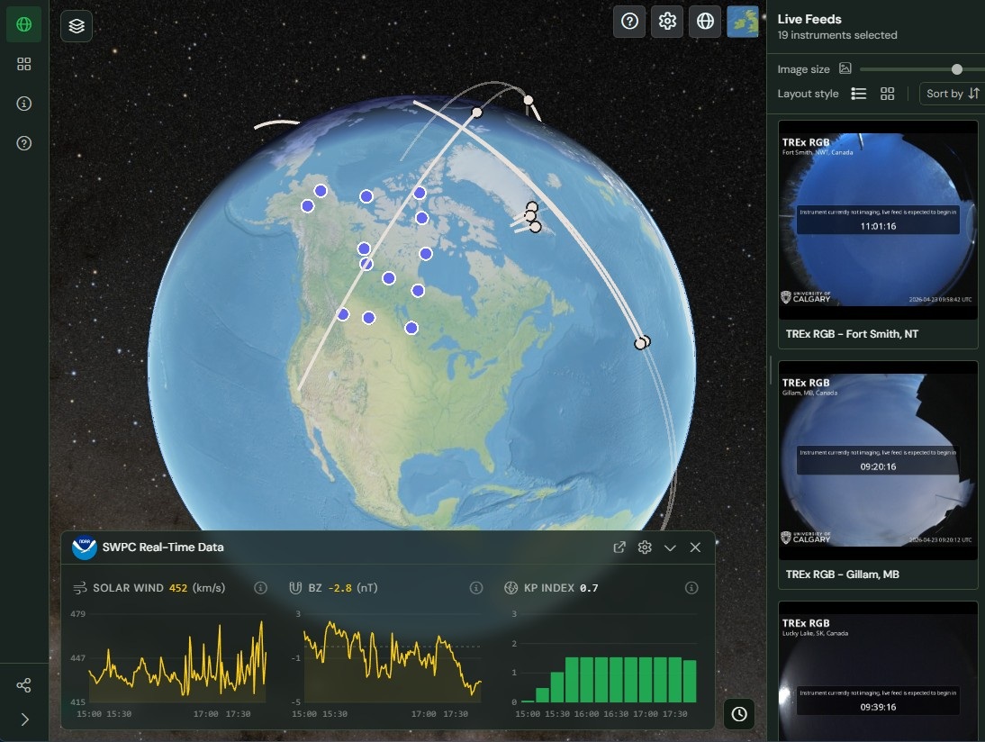
April 8, 2026Apr 8AuroraX Real-Time Viewer releasedAuroraX
The new AuroraX Real-Time Viewer has been released. This interactive tool displays live auroral imagery from camera networks across the globe on a 3D map, along with real-time spacecraft positions and space weather data from NOAA SWPC. Read more in our news post.
March 12, 2026Mar 12New Data Volume page addedWebsite
We have added a new Data Volume page to this website, providing a summary of the data included in the SRS Open Science Platform. The page features an interactive chart showing data volume and file counts broken down by dataset or general category.
Latest News
0:00 / 0:00
Our Data
Browse our open data archive. The archive is accessible using a variety of methods, including HTTP, FTP, Rsync, Python libraries, IDL library, and direct API-based access.
- HTTP:by project, by instrument type
- Rsync:
rsync rsync://data.phys.ucalgary.ca - FTP:
ftp://data.phys.ucalgary.ca - API:api.phys.ucalgary.ca
- View thestatus of the platform
- Explore thearchive data volume
- Explore thedataset documentation
0:00 / 0:00
Working with our Data
We provide several libraries for working with our data, along with a vast example gallery. Tools are for Python and IDL, along with a RESTful API available for direct interaction.
- Explore oursoftware packages
- Learn how todownload data
- Explore the crib sheets:Python, IDL
- New to our data? Follow ourlearning pathsto get started
- Writing a paper? Learnhow to citeuse of our datasets and tools
- Learn about theAPI
Data Discovery & Visualizations
Explore our data through a variety of websites and visualizations developed to support exploration and discovery of our data.
Learn MorePlatform at a Glance
The archive contains 1.167 PB of data across 706,209,241 files. Last scanned June 1, 2026.
Publications per Year
Frequently Asked Questions
How do I properly acknowledge and cite the data I'm using?
Each dataset contains an acknowledgements file housed in the appropriate data tree. The file contains required data acknowledgements and/or the DOI for the dataset (e.g., REGO). You can also consult the list of datasets to find links to appropriate acknowledgements file. If you cannot find what you are looking for, please reach out.
I think something is wrong, who do I contact about the data I'm using?
If you encounter issues or have questions about the data please reach out to the instrument contact listed on the Dataset Documentation page.
Can you change the operating mode of the sensors to support my science?
Some UCalgary instrumentation has capacity for different operating modes. If you are interested in discussing operational modes, please reach out to the contact for the appropriate instrument type/network.
Are there any new sensors planned for the near future?
We are always looking for ways to improve the quality and information content of our data. This can be modifications to operational modes, calibration procedures, or designing next generation instrumentation. Currently, SMILE-ASI is in active development, with GDC-G following closely behind. If you are interested in learning more, please reach out the UCalgary team.
How do I get last night's full resolution data?
Depending on the instrument type, full resolution data may not be available in real-time. Higher data rate systems (e.g., ASIs) often rely on physical recovery of hard drives with a 3-6 month lag for data to be available. Our data archive is built on a philosophy of 'if we have it, you have it', so for our fully operational systems if you do not see full resolution data, it is very likely still in the field. For high-value data, and on request, we can sometimes retrieve portions of large datasets (e.g., an hour of data). If you have a specific data request please reach out to the instrument contact.
Have Questions?
If you have any questions, please don't hesitate to contact us.