TREx Blueline#

TREx-Blueline is part of the Canada Foundation for Innovation, Transition Region Explorer (TREx) sensor web. TREx-Blueline is a network of narrow-band filtered (427.8nm) ASIs strategically deployed to bracket the ionospheric footprint of the Nightside Transition Region (NTR). TREx-Blueline nominally records 3s images but is capable of burst mode acquisition up to 10Hz.


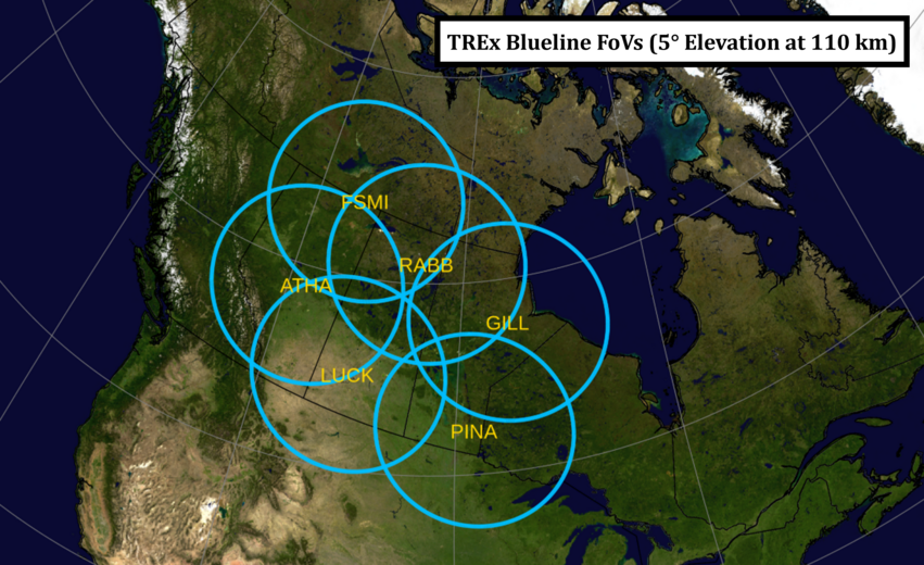
View hi-res 5 degree elevation angle version
View 10 degree elevation angle version
View hi-res 10 degree elevation angle version

Observatories#

UIDFull NameGeodetic LatitudeGeodetic Longitude
athaAthabasca, AB, Canada54.60-113.64
fsmiFort Smith, NWT, Canada60.03-111.93
gillGillam, MB, Canada56.38-94.64
luckLucky Lake, SK, Canada51.15-107.26
pinaPinawa, MB, Canada50.26-95.87
rabbRabbit Lake, SK, Canada58.23-103.68

API Datasets#

Common datasets:

  • TREX_BLUE_RAW

  • TREX_BLUE_SKYMAP_IDLSAV

Dataset NameDescription
TREX_BLUE_CALIBRATION_FLATFIELD_IDLSAVTREx Blueline All Sky Imagers Flatfield calibration data (IDL save format)
TREX_BLUE_CALIBRATION_RAYLEIGHS_IDLSAVTREx Blueline All Sky Imagers Rayleighs calibration data (IDL save format)
TREX_BLUE_DAILY_KEOGRAM_PGMTREx Blueline All Sky Imagers daily keogram summary product (PGM format)
TREX_BLUE_DAILY_KEOGRAM_PNGTREx Blueline All Sky Imagers daily keogram summary product (PNG format)
TREX_BLUE_DAILY_MONTAGE_PGMTREx Blueline All Sky Imagers daily montage summary product (PGM format)
TREX_BLUE_DAILY_MONTAGE_PNGTREx Blueline All Sky Imagers daily montage summary product (PNG format)
TREX_BLUE_GRID_MOSV001TREx Blueline All Sky Imagers MOSv001 verified grid files (raw data, intensity grid priority)
TREX_BLUE_HOURLY_KEOGRAM_PGMTREx Blueline All Sky Imagers hourly keogram summary product (PGM format)
TREX_BLUE_HOURLY_KEOGRAM_PNGTREx Blueline All Sky Imagers hourly keogram summary product (PNG format)
TREX_BLUE_HOURLY_MONTAGE_PGMTREx Blueline All Sky Imagers hourly montage summary product (PGM format)
TREX_BLUE_HOURLY_MONTAGE_PNGTREx Blueline All Sky Imagers hourly montage summary product (PNG format)
TREX_BLUE_RAWTREx Blueline All Sky Imagers 3-sec raw data
TREX_BLUE_SKYMAP_IDLSAVTREx Blueline All Sky Imagers skymap data (IDL save format)

Dataset Detailed Descriptions#

TREX_BLUE_RAW#

The primary dataset used by the analysis support software, and the dataset that most users utilize.

TREX_BLUE_GRID_MOSV001#

Verified grid file dataset, version 001. Dataset generation details will be available shortly.